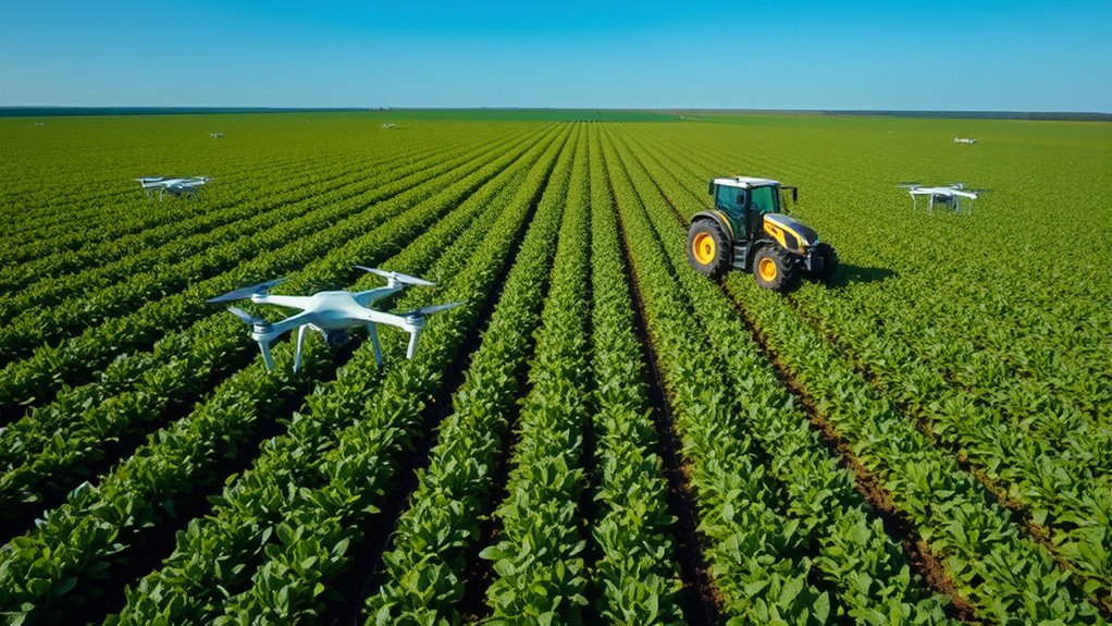
Precision agriculture uses GPS, drones, and sensors to help you farm more efficiently and sustainably. GPS maps your fields so you can target specific areas with precision. Drones and multispectral cameras provide detailed images that reveal crop stress and health issues quickly. Sensors in the soil give real-time data on moisture, nutrients, and pH, allowing you to make informed decisions. Keep exploring to discover how these tools can transform your farming practices.
Key Takeaways
- Precision agriculture uses GPS technology to map fields and create management zones for targeted farming practices.
- Drones equipped with multispectral cameras monitor crop health, detecting issues like pests or diseases early.
- Soil sensors provide real-time data on moisture, nutrients, and pH, enabling precise input application.
- Integration of GPS, drones, and sensors allows for data-driven decisions that optimize yields and reduce resource waste.
- These advanced tools promote sustainable farming by minimizing chemical use and improving overall soil and crop management.

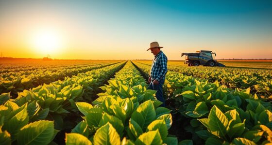
Have you ever wondered how technology is transforming farming practices? Today’s farmers are harnessing advanced tools like GPS, drones, and sensors to improve efficiency and sustainability. These innovations are reshaping traditional agriculture, making it possible to manage fields with unprecedented precision. One of the key aspects of this transformation is how farmers now prioritize soil health. By monitoring soil conditions more accurately, they can optimize inputs such as water, fertilizers, and pesticides, reducing waste and environmental impact. Sensors placed in the ground provide real-time data on moisture levels, nutrient content, and pH, giving you a detailed picture of your soil’s health. With this information, you can make informed decisions about when and where to apply treatments, ensuring your crops receive exactly what they need without overdoing it. This targeted approach not only boosts crop yields but also preserves your land’s long-term productivity. Precision farming technologies are also enabling the integration of data from multiple sources, creating a comprehensive view of farm conditions.
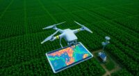
Crop monitoring is another critical element influenced by these technological advances. Drones equipped with multispectral cameras fly over your fields, capturing high-resolution images that reveal variations in crop health. These images help you identify areas where plants may be stressed due to pests, disease, or nutrient deficiencies. Instead of blanket treatments across the entire field, you can focus on specific zones that require attention, saving you money and reducing chemical use. GPS technology further enhances this process by mapping your fields with precision, allowing you to create detailed management zones. When combined with sensor data, you gain a detailed understanding of your crops’ status at any given moment, enabling you to react swiftly to emerging issues. This proactive approach minimizes damage and maximizes productivity.

SMA10 Tractor GPS Guidance System for Agriculture, Precision Farming Navigation System with PPP and SBAS, 10cm Accuracy by PPP, 2.5cm by RTK High Accuracy Anti-Interference GNSS Antenna
【High-Precision Positioning Technology】The SMA10 GPS for tractors for spraying integrates multiple positioning technologies including PPP,SBAS and RTK ensuring…
As an affiliate, we earn on qualifying purchases.
As an affiliate, we earn on qualifying purchases.
Frequently Asked Questions
How Does GPS Improve Crop Yield Accuracy?
GPS improves crop yield accuracy by enabling precise crop monitoring across your fields. With GPS technology, you can collect detailed data on soil health, moisture levels, and crop conditions, ensuring your decisions are based on accurate information. This enhances data accuracy, allowing you to target specific areas for treatment or intervention. As a result, you optimize inputs, reduce waste, and ultimately increase your crop yields efficiently and effectively.
What Are the Initial Costs of Implementing Drone Technology?
You’ll find the initial costs of implementing drone technology vary, but expect to spend around $1,500 to $25,000 for a basic system. This includes drone purchase, sensors, and software. Don’t forget ongoing expenses like drone maintenance and adhering to legal regulations, which can add to your budget. While the upfront cost may seem high, the long-term benefits in crop monitoring and yield improvement often outweigh these initial investments.
How Do Sensors Detect Soil Nutrient Levels?
You can detect soil nutrient levels with sensors by performing soil testing and nutrient mapping directly in the field. These sensors analyze soil properties such as pH, moisture, and nutrient concentrations in real-time. They send data to a central system, which creates detailed nutrient maps. These maps help you identify nutrient deficiencies or excesses, allowing for precise fertilization and better crop management, ultimately improving yields and reducing waste.
Can Small Farms Afford Precision Agriculture Tools?
Small farms can definitely afford precision agriculture tools despite cost barriers. Many affordable options exist, like entry-level GPS devices and basic sensors that improve efficiency without breaking the bank. You can start small, focusing on essential equipment that offers quick returns. As you see benefits, you might invest in more advanced tools. With careful planning and choosing cost-effective equipment, precision agriculture becomes accessible and practical for small farm operations.
What Environmental Impacts Do Drones Have?
Drones can impact the environment through noise pollution and wildlife disturbance. Their noise, though often minimal, can stress animals and disrupt their natural behaviors. You might notice wildlife avoiding areas where drones frequently fly. To minimize these effects, you should operate drones quietly and avoid flying during sensitive times like nesting seasons. Responsible use helps balance agricultural benefits with protecting local ecosystems.
Drone with 2K Camera for Adults, RC Quadcopter with Obstacle Avoidance, 40 Minute Flight, Altitude Hold, One-Key Takeoff/Landing, 3 Speed Modes, Headless Mode, Best Gifts for Beginners
Clear Imaging: Use a 4K high-definition camera to capture stunning photos and smooth videos. The drone camera has…
As an affiliate, we earn on qualifying purchases.
As an affiliate, we earn on qualifying purchases.
Conclusion
As you harness GPS, drones, and sensors, the future of farming transforms before your eyes. Imagine fields that know exactly what they need, where every acre responds to precise data. You stand at the edge of innovation, ready to unseal yields like never before. But as technology advances, questions remain—what’s next in this digital agricultural revolution? Stay tuned, because the next breakthrough could redefine how you cultivate your land forever.

AITRIP 10 Pack Capacitive Soil Moisture Sensor Corrosion Resistant for Arduino Moisture Detection Garden Watering DIY Electronic for Arduino and Raspberry Pi (10PCS)
This capacitive soil moisture sensor is distinguished from most resistive sensors on the market and uses capacitive sensing…
As an affiliate, we earn on qualifying purchases.
As an affiliate, we earn on qualifying purchases.

Precision Agriculture with Drones: Smart Farming, NDVI Imaging & Crop Monitoring for Modern Agripreneurs
As an affiliate, we earn on qualifying purchases.
As an affiliate, we earn on qualifying purchases.