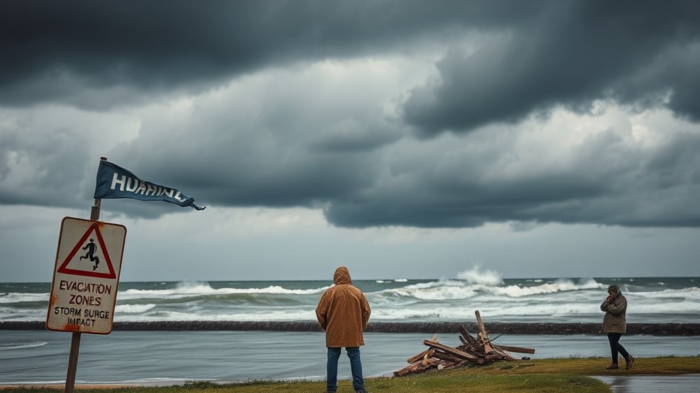

Knowing your evacuation zones and storm surge risks is essential for effective hurricane prep. It helps you decide when to evacuate, choose safe routes, and avoid flood-prone areas. Understanding these zones also protects your property and belongings from storm surge damage. Staying informed about marine conditions and updating your emergency plans makes sure you’re ready if a hurricane strikes. To learn more about how to stay safe and plan ahead, keep exploring these important topics.
Key Takeaways
- Identify and follow official evacuation zone maps to ensure safe evacuation routes during hurricanes.
- Stay informed about storm surge risk zones to avoid flooding and protect property and vessels.
- Update marine navigation charts regularly to navigate safely and avoid surge-prone areas at sea.
- Secure boats and belongings early, and develop a clear evacuation plan for both land and water.
- Review insurance policies to confirm coverage for storm surge damage and document assets before storms arrive.

Have you ever wondered if you’re fully prepared for a hurricane? Knowing your evacuation zone is a vital step in hurricane preparedness, especially if you rely on marine navigation. If you own a boat or plan to be on the water during a storm, understanding how hurricanes can impact marine routes is essential. Storm surge, which can raise water levels dramatically, poses a significant threat to both land and watercraft. By familiarizing yourself with local evacuation zones, you can avoid dangerous areas prone to flooding and storm surge. This knowledge helps you make quick decisions about when to evacuate and where to seek shelter, reducing the risk of injury or damage. It’s also wise to check if your insurance policy covers damage caused by storm surge, as many standard policies exclude these events. This way, if your property or vessel sustains damage, you’re prepared to file insurance claims smoothly and efficiently.
Knowing your evacuation zone isn’t just about personal safety; it’s also about protecting your assets and ensuring you’re ready to act when the time comes. For boat owners, marine navigation charts often highlight areas at risk of flooding or storm surge. Keeping these charts handy and updating them regularly can help guide you safely away from dangerous waters. When a hurricane approaches, staying informed through official updates and monitoring marine navigation alerts can prevent you from venturing into hazardous areas. This proactive approach minimizes the chances of running into trouble on the water, where storm surge and high winds can be deadly.
Preparing for a hurricane involves more than just knowing your evacuation zone. It’s about having a plan in place for quick evacuation, securing your property, and understanding how storm surge might impact your area. If you own a boat, make sure it’s stored in a safe location or secured properly to withstand high water levels. Keep copies of your insurance policies, and document your property and vessel’s condition before the storm hits. This documentation is invaluable when filing insurance claims afterward, especially if storm surge causes extensive damage.
Frequently Asked Questions
How Are Evacuation Zones Determined and Updated?
You can find out how evacuation zones are determined and updated by checking local government alerts. Emergency zone updates occur regularly based on new storm data, flood risk assessments, and changing weather patterns. Authorities analyze evacuation zone boundaries using geographic information systems (GIS) and flood models. They update these zones to guarantee safety, so stay informed through official channels to know when your zone boundaries change and if you need to evacuate.
What Are the Criteria for Storm Surge Alerts?
You get a storm surge alert based on detailed storm surge modeling and flood risk assessments. Authorities analyze data like storm intensity, size, and forecasted path to predict potential surge levels. If models indicate a significant surge that could flood low-lying areas, alerts are issued. These criteria help you prepare or evacuate if necessary, ensuring safety by relying on the most current flood risk assessments and storm surge predictions.
How to Prepare an Emergency Kit for Hurricane Evacuation?
Did you know that having an emergency kit ready can increase your chances of safety during a hurricane? To prepare, gather emergency supplies like water, non-perishable food, medications, and flashlight. Include important documents and a first-aid kit. Create a communication plan with family members, so everyone knows how to stay in touch. Keep your kit in an accessible spot and update it regularly to guarantee you’re ready to evacuate quickly.
What Transportation Options Are Available During Evacuation?
During evacuation, you can use public transportation options like buses, trains, or emergency shuttles if available in your area. It’s also smart to prepare your private vehicle by ensuring it’s fueled, with an emergency kit ready, and navigation tools handy. Consider your transportation options early, plan your route, and stay informed through local alerts to avoid delays and stay safe during the evacuation process.
How Do Storm Surge Maps Predict Flooding Levels?
Storm surge maps predict flooding levels using storm surge modeling, which estimates how high water could rise during a hurricane. You can understand flood risk assessment by examining these maps, which highlight areas prone to flooding based on storm intensity, tide levels, and coastline geography. By analyzing this data, you can determine which zones are most vulnerable, helping you make informed evacuation decisions and stay safe during a storm.
Conclusion
Remember, hurricane preparedness is your anchor in a stormy sea. Knowing your evacuation zones and understanding storm surge risks keeps you steady when chaos surrounds you. Think of it as having a lighthouse guiding you safely through turbulent waters—your plan lights the way when darkness looms. Stay informed, stay ready, and don’t let fear be your captain. With preparation, you can navigate even the roughest storms, emerging stronger on the other side.